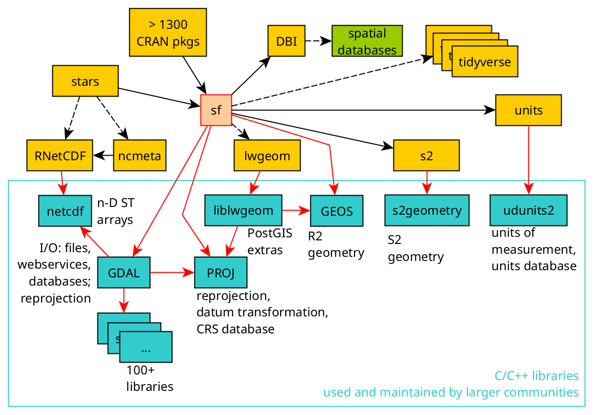
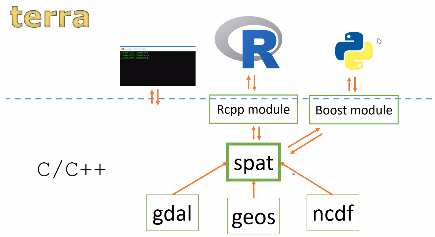
Not to be confused with R-spatial, the Rspatial resources include a different way to handle geospatial data in R. The main package {terra} provides classes and methods to represent raster and vector objects. It works well on large data sets and is a fast implementation mainly because it is written directly in C++. This means that, for example, a Python module could also be built on top of this library. {terra} is based on C++ modules like gdal, geos and ncdf and builds it’s own spat module on C++ that interacts with R via the Rcpp module.
Allaire, JJ. 2023.
Quarto: R Interface to Quarto Markdown Publishing System.
https://github.com/quarto-dev/quarto-r.
Appelhans, Tim, Florian Detsch, Christoph Reudenbach, and Stefan Woellauer. 2022.
Mapview: Interactive Viewing of Spatial Data in r.
https://github.com/r-spatial/mapview.
Aydin, Orhun, Dmitry Pavlushko, Shaun Walbridge, Steve Kopp, and Mark V. Janikas. 2024.
“Arcgisbinding: An r Package for Integrating r and ArcGIS.” Environmental Modelling &Amp; Software 172 (January): 105904.
https://doi.org/10.1016/j.envsoft.2023.105904.
Bishwal, R. M. 2017.
“Potential Use of r-Statistical Programming in the Field of Geoscience.” In
2017 2nd International Conference for Convergence in Technology (I2CT), 979–82.
https://doi.org/10.1109/I2CT.2017.8226275.
Bivand, Roger. 2024.
Rgrass: Interface Between ’GRASS’ Geographical Information System and ’r’.
https://rsbivand.github.io/rgrass/.
Brenning, Alexander, Donovan Bangs, and Marc Becker. 2022.
RSAGA: SAGA Geoprocessing and Terrain Analysis.
https://CRAN.R-project.org/package=RSAGA.
Câmara, Gilberto, Rolf Simoes, Felipe Souza, Charlotte Pelletier, Alber Sanchez, Pedro Andrade, Karine Ferreira, and Gilberto Queiroz. 2023.
“sits: Satellite Image Time Series Analysis on Earth Observation Data Cubes.” 2023.
https://e-sensing.github.io/sitsbook/index.html.
Dunnington, Dewey, Floris Vanderhaeghe, Jan Caha, and Jannes Muenchow. n.d.
“R Package Qgisprocess: Use QGIS Processing Algorithms.” https://github.com/r-spatial/qgisprocess/.
Hijmans, Robert. 2020.
“Terra and Luna: New r Packages Scalable Geospatial Data Analysis.” Big Data in Agriculture - 2020 Convention. 2020.
https://www.youtube.com/watch?v=5b2xhqlH49I&t=690s.
Hijmans, Robert J. 2024.
Terra: Spatial Data Analysis.
https://rspatial.org/.
Lovelace, Robin, Jakub Nowosad, and Jannes Muenchow. 2019. Geocomputation with R. CRC Press.
Pebesma, Edzer. 2018.
“Simple Features for R: Standardized Support for Spatial Vector Data.” The R Journal 10 (1): 439–46.
https://doi.org/10.32614/RJ-2018-009.
———. 2023a.
Sf: Simple Features for r.
https://r-spatial.github.io/sf/.
———. 2023b.
Stars: Spatiotemporal Arrays, Raster and Vector Data Cubes.
https://r-spatial.github.io/stars/.
Pebesma, Edzer, and Roger Bivand. 2023b.
Spatial Data Science: With applications in R.
Chapman and Hall/CRC.
https://doi.org/10.1201/9780429459016.
———. 2023a.
Spatial Data Science: With applications in R. London: Chapman; Hall/CRC.
https://doi.org/10.1201/9780429459016.
Pebesma, Edzer, Thomas Mailund, and James Hiebert. 2016.
“Measurement Units in R.” R Journal 8 (2): 486–94.
https://doi.org/10.32614/RJ-2016-061.
Pebesma, Edzer, Thomas Mailund, Tomasz Kalinowski, and Iñaki Ucar. 2023.
Units: Measurement Units for r Vectors.
https://r-quantities.github.io/units/.
R Core Team. 2023.
R: A Language and Environment for Statistical Computing. Vienna, Austria: R Foundation for Statistical Computing.
https://www.R-project.org/.
Reudenbach, Chris. 2023.
link2GI: Linking Geographic Information Systems, Remote Sensing and Other Command Line Tools.
https://CRAN.R-project.org/package=link2GI.
Slater, Louise J., Guillaume Thirel, Shaun Harrigan, Olivier Delaigue, Alexander Hurley, Abdou Khouakhi, Ilaria Prosdocimi, Claudia Vitolo, and Katie Smith. 2019.
“Using r in Hydrology: A Review of Recent Developments and Future Directions.” Hydrology and Earth System Sciences 23 (7): 2939–63.
https://doi.org/10.5194/hess-23-2939-2019 .
Tennekes, Martijn. 2018.
“tmap: Thematic Maps in R.” Journal of Statistical Software 84 (6): 1–39.
https://doi.org/10.18637/jss.v084.i06.
———. 2023.
Tmap: Thematic Maps.
https://github.com/r-tmap/tmap.
Wickham, Hadley. 2016.
Ggplot2: Elegant Graphics for Data Analysis. Springer-Verlag New York.
https://ggplot2.tidyverse.org.
Wickham, Hadley, Winston Chang, Lionel Henry, Thomas Lin Pedersen, Kohske Takahashi, Claus Wilke, Kara Woo, Hiroaki Yutani, Dewey Dunnington, and Teun van den Brand. 2024.
Ggplot2: Create Elegant Data Visualisations Using the Grammar of Graphics.
https://ggplot2.tidyverse.org.
Xie, Yihui. 2014. “Knitr: A Comprehensive Tool for Reproducible Research in R.” In Implementing Reproducible Computational Research, edited by Victoria Stodden, Friedrich Leisch, and Roger D. Peng. Chapman; Hall/CRC.
———. 2015.
Dynamic Documents with R and Knitr. 2nd ed. Boca Raton, Florida: Chapman; Hall/CRC.
https://yihui.org/knitr/.
———. 2023.
Knitr: A General-Purpose Package for Dynamic Report Generation in r.
https://yihui.org/knitr/.


